
본 홈페이지는 국립기상과학원 ARGO 프로그램 현황 및 자료 제공을 위해 운영되고 있으며, 국제자료센터와 연계하여 전지구 자료도 함꼐 제공되고 있습니다.
각 메뉴의 기능은 아래와 같습니다.
ARGO 플로트에 대한 소개와 품질관리 방법, 관련 사이트를 제공합니다.
국립기상과학원에서 투하한 ARGO 플로트의 관측 현황과 각 자료의 궤적, 연직 프로파일, TS-diagram 등을 제공하며, 자료 다운로드 기능도 제공합니다.
실시간 및 지연모드 품질관리를 통해 생산된 전지구 자료를 제공합니다.
ARGO 프로그램에서 개최하는 AST, ADMT 회의 결과와 ARGO 플로트 투하 및 운영과 관련된 이미지를 제공합니다.
HOME > ARGO Introduction > ARGO Float
The National Institute of Meteorological Sciences ARGO (NIMS-ARGO) program is an international cooperation program for global ocean observation performed by the World Meteorological Organization/Intergovernmental Oceanographic Commission of UNESCO (WMO/IOC). The objectives of this project is to do near-real time monitoring the upper ocean from monthly to decadal scale variation, and to describe the ocean climate change quantitatively.
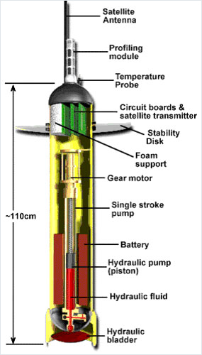
The Argo floats carry out profiling of the water temperature, salinity, Chlorophyll, and Nitrogen for the physical and biogeochemical study of ocean. This program started from early 2000 and 16 countries and several institutes and university in the world are participating in deploying more 800 floats every year.
As an international global ocean observation program, it is also connected with Global Climate Observing System/Global Ocean Observing System (GCOS/GOOS), Climate Variability and Predictability program (CLIVAR), and Global Ocean Data Assimilation Experiment (GODAE).
ARGO I Video
ARGO II Video
(soruce: ARGO Program, http://argo.ucsd.edu)
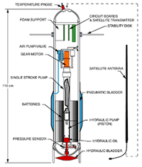
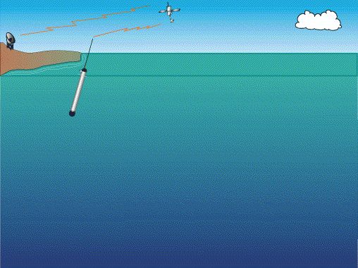
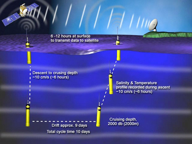
ARGO float is designed to go down to specified depth and drift for determined time along geostrophic current.
Then it observes the temperature and salinity of the layers as it rises up to the surface layer by internal dynamics, and transmits the recorded data to ARGOS satellite.
The observed data will be sent to ARGOS center and processed by quality control. Then the final data will be distributed to the ARGO participating country via GTS, FTP and e-mail.
http://www.coriolis.eu.org/Observing-the-Ocean/ARGO
https://nrlgodae1.nrlmry.navy.mil/argo/argo.html
http://biogeochemical-argo.org/index.php
http://imos.org.au/facilities/argofloats
http://www.coriolis.eu.org/Observing-the-Ocean/ARGO
http://www.incois.gov.in/Incois/argo/argo_home.jsp
http://www.jamstec.go.jp/J-ARGO/index_e.html
http://www.aoml.noaa.gov/phod/argo/index.php
http://apdrc.soest.hawaii.edu/argo
https://incois.gov.in/argo/ARDCenter.jsp
http://www.argodatamgt.org/Argo-regional-Centers/North-Atlantic-ARC
http://www.aoml.noaa.gov/phod/sardac/index.php
http://www.ukargo.net/southern_ocean_argo_regional_centre
http://nettuno.ogs.trieste.it/sire/medargo
http://www.wmo.int/pages/prog/gcos/index.php
http://sealevel.jpl.nasa.gov/missions/
http://sealevel.jpl.nasa.gov/missions/topex
http://goosocean.org/index.php?option=com_content&view=article&id=124&Itemid=281
https://www.godae-oceanview.org/
 ARGO National Institute of Meteorological Sciences